Q1 Charting Your Course
Introduction
Efficient travelers move between point A to point B as quickly as possible, using whatever transportation is available. This means you could be driving, walking, or taking the local bus. But how do you know which one is best for the situation?
Google Maps lets you fly anywhere on Earth to view satellite imagery, maps and terrain. You can explore rich geographical content and with a free account, save to "my Maps", and share with others. On this quest you will be charting your own course. Follow the steps below to learn how!
Key Vocabulary:
Interactives: Interactives are media such as text, graphics, animation, video, audio, games, etc. designed to respond to the actions, commands, etc., of a user
relative location: is the location of a subject in relation to another point e.g. she lives next to the railroad tracks
absolute location: is directly where a person or place is located
modes: types or forms
Steps:
PART 1 - MAPPING
1. Start off by watching the video below. It's a basic overview of Google Maps at Youtube. (If Youtube is blocked, check out this Vimeo Video about Google Maps).

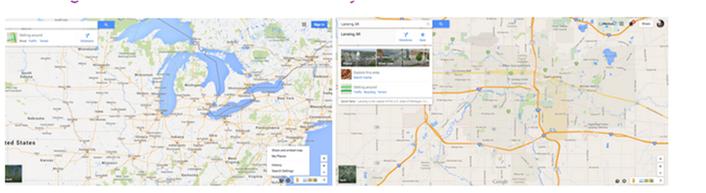
2. Now go to maps.google.com
3. Locate the search window at the top left. Click on the blue diamond with white arrow for directions.
3. Locate the search window at the top left. Click on the blue diamond with white arrow for directions.

PART 2 - GET DIRECTIONS FROM HOME TO SCHOOL
You will need your home address, the name of your school, and the city and state where your school is located.
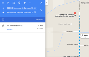
4. On the top line, type your home address. On the second line, type the name of your school, the city and state your school is located in. (NOTE: If Google Maps is unable to find your school by name, you can type the school address on the line).
5. Compare the time for walking, driving, and by bicycle by clicking on the icons. Select the one that best fits for the way you get to school.
6. Take a screenshot of your map showing the route and paste it into a word processing document and save it (titled "my map") in your file space. Also paste the link to your map in your document by clicking on the link icon as shown in the video above.
PART 3 - A LINK TO SOCIAL STUDIES
7. The next step is to find your absolute location.
- * Right-click (or on a mac control-click) on the marker for your home.
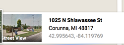
- * Click on "What's here?"
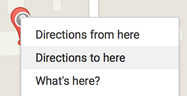
- * the latitude and longitude coordinates are shown at the bottom next to a streetview image. It will look something like (42.995643, -84.119769) and is referred to as your "absolute location."
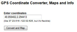
- * Copy the latitude and longitude coordinates and type or paste them into this GPS converter to discover how these are represented as GPS directions. What is the difference? (Learn more about "Absolute location")
9. Now let's find your relative location to the Capitol of the United States.
Here is the location of the Capitol in Washington, DC:
Address: The United States Capitol is located at First St SE in Washington, DC 20004.
Absolute location of the U.S. Capitol in latitude/longitude is 38° 53′ 35″ N, 77° 00′ 32″ W.
Relative location: An example of relative location is that the U.S. Capitol is located 598 miles South East of Corunna, MI.
A. Using the Google maps or alternative mapping program, figure out the relative location of the Capitol of the U.S. to your school.
B. Now find the relative location of your school to one of the U.S. national landmarks listed below:
Yellowstone Park
Grand Canyon
Mount Rushmore
Pictured Rocks
Statue of Liberty
Lincoln Memorial
C. Write a paragraph describing the national landmark you selected, if you would like to visit it someday, and how long it would take you to get there from your school including what transportation you chose (walk, bike, drive, fly).
NETS
4. Critical Thinking, Problem Solving,and Decision Making
Students use critical thinking skills to plan and conduct research, manage projects, solve problems,
and make informed decisions using appropriate digital tools and resources.
Common Core Standards
CCSS.ELA-Literacy.RH.6-8.7 Integrate visual information (e.g., in charts, graphs, photographs, videos, or maps) with other information in print and digital texts.
CCSS.ELA-Literacy.RST.6-8.4 Determine the meaning of symbols, key terms, and other domain-specific words and phrases as they are used in a specific scientific or technical context relevant to grades 6–8 texts and topics.
CCSS.ELA-Literacy.RST.6-8.7 Integrate quantitative or technical information expressed in words in a text with a version of that information expressed visually (e.g., in a flowchart, diagram, model, graph, or table)
CCSS.ELA-Literacy.CCRA.L.6 Acquire and use accurately a range of general academic and domain-specific words and phrases sufficient for reading, writing, speaking, and listening at the college and career readiness level; demonstrate independence in gathering vocabulary knowledge when encountering an unknown term important to comprehension or expression.
